File : D1.6
Author : Paul Ruyssenaars (RIVM)
The aim of the network meetings is to bring together experts from National GHG inventory (NGHGI) Agencies and the climate and emission scientists/modelers (CES/M), to contribute to achieving the overall objectives of the project. The ultimate aim of the project is to use the improved knowledge of GHG budgets from VERIFY to improve national inventories, in collaboration with national inventory agencies. Based on the presentations and discussion during this meeting, we can summarize the main differences between both “worlds” (emission inventorying and modelling/measurements) as follows:
|
NGHGI |
CES/M |
|
|
Temporal scale |
Low resolution: |
High resolution: |
|
Spatial scale |
Low resolution: Territorial, country specific (per Member State) |
High resolution of spatially disaggregated data, applicable for - regional/global coverage without political border - local scale for verification of e.g. large point sources |
|
Activity link |
Fine granularity: Disaggregated by source, subsector, human activity specific |
Course granularity: Larger groups of activities for which spatial and temporal data are available, of interest for near real time emission assessment |
|
Challenges |
Direct/indirect emissions, uncertainties, increased complexity |
Modeling of processes, biofuel/biomass, Carbon Capture and Storage. |
Inventory experts operate in the context of- and within the boundaries of the UNFCCC reporting guidelines and IPCC emission inventory guidelines. Reporting at a higher spatial/temporal resolution would be beneficial for independent verification, but is as yet outside the scope of formal/legal requirements. However, this meeting shows there is scope for better collaboration between emission inventory experts and modelling& measurement experts.
Scientists have made progress over the past few years in developing methodologies that may help in both comparison of- and verifying the inventories. Tools are made available through the LSCE VERIFY website. There is a huge potential e.g. in developing and applying Earth Observation tools; but also inverse modelling. An extension of the measurement network over Europe might be beneficial in this context.
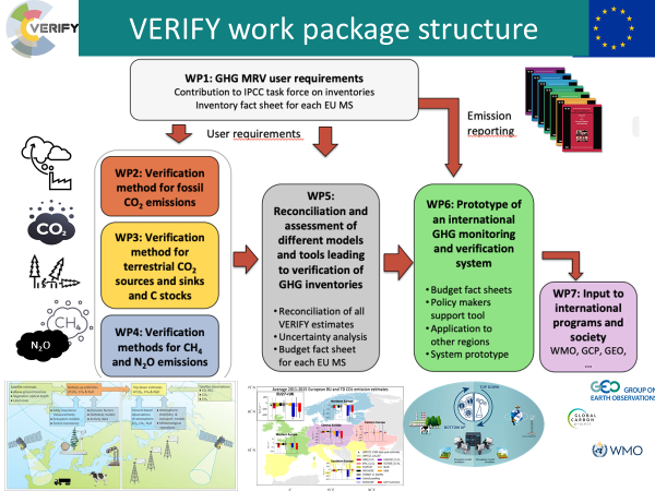
Figure 1 : Schematic overview of VERIFY structure